


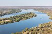
The Zambezi (also spelled Zambesi) is the fourth-longest river in Africa, and the largest flowing into the Indian Ocean from Africa. The area of its basin is 1,390,000 km² (537,000 miles²), slightly less than half that of the Nile. The 3,540 km- (2,200 mile-) long river has its source in Zambia and flows through Angola, along the borders of Namibia, Botswana, Zambia, and Zimbabwe, to Mozambique, where it empties into the Indian Ocean.
The Zambezi's most spectacular feature is the beautiful Victoria Falls. Other notable falls include the Chavuma Falls at the border between Zambia and Angola, and Ngonye Falls, near Sioma in Western Zambia.
There are two main sources of hydroelectric power on the river. These are the Kariba Dam, which provides power to Zambia and Zimbabwe and the Cahora Bassa Dam in Mozambique which provides power to both Mozambique and South Africa. There is also a smaller power station at Victoria Falls.
The river rises in a black marshy dambo in north-western Zambia, in undulating miombo woodland, quite dense in parts, about 1,524 m (4,900 ft) above sea level. Eastward of the source, the watershed between the Congo and Zambezi basins is a well-marked belt of high ground, falling abruptly north and south, and running nearly east-west. This distinctly cuts off the basin of the Lualaba (the main branch of the upper Congo) from that of the Zambezi. In the neighbourhood of the source the watershed is not as clearly defined, but the two river systems do not connect.
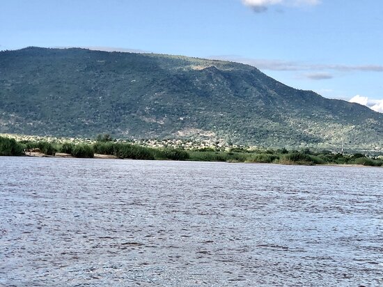
The region drained by the Zambezi is a vast broken-edged plateau 900–1200 m high, composed in the remote interior of metamorphic beds and fringed with the igneous rocks of the Victoria Falls. At Shupanga, on the lower Zambezi, thin strata of grey and yellow sandstones, with an occasional band of limestone, crop out on the bed of the river in the dry season, and these persist beyond Tete, where they are associated with extensive seams of coal. Coal is also found in the district just below the Victoria Falls. Gold-bearing rocks occur in several places.
The river flows to the south-west and into Angola for about 240 kilometres (150 mi), then is joined by sizeable tributaries such as the Luena and the Chifumage flowing from highlands to the north-west. It turns south and develops a floodplain and becomes very variable in width between the dry and rainy seasons. It enters a region with dense patches of evergreen Cryptosepalum dry forest, though on its western side, Western Zambezian grasslands also occur. Where it re-enters Zambia it is nearly 400 metres (1,300 ft) wide in the rainy season and flows quite quickly with rapids ending in the Chavuma Falls, where the river flows through a rocky fissure. The river drops about 400 metres (1,300 ft) in elevation from its source at 1,500 metres (4,900 ft) to the Chavuma Falls at 1,100 metres (3,600 ft), in a distance of about 400 kilometres (250 mi). From this point to the Victoria Falls, the level of the basin is very uniform, dropping only by another 180 metres (590 ft) in a distance of around 800 kilometres (500 mi).
The first of its large tributaries to enter the Zambezi is the Kabompo River in the north-western province of Zambia. The savanna through which the river has flowed gives way to a wide floodplain, studded with Borassus fan palms. A little farther south is the confluence with the Lungwebungu River. This is the beginning of the Barotse Floodplain, the most notable feature of the upper Zambezi, but this northern part does not flood so much and includes islands of higher land in the middle
Thirty kilometres (20 mi) below the confluence of the Lungwebungu the country becomes very flat, and the typical Barotse Floodplain landscape unfolds, with the flood reaching a width of 25 kilometres (16 mi) in the rainy season. For more than 200 kilometres (120 mi) downstream the annual flood cycle dominates the natural environment and human life, society and culture.
Eighty kilometres (50 mi) further down, the Luanginga, which with its tributaries drains a large area to the west, joins the Zambezi. A few kilometres higher up on the east the main stream is joined in the rainy season by overflow of the Luampa/Luena system.
A short distance downstream of the confluence with the Luanginga is Lealui, one of the capitals of the Lozi people who populate the Zambian region of Barotseland in Western Province. The chief of the Lozi maintains one of his two compounds at Lealui; the other is at Limulunga, which is on high ground and serves as the capital during the rainy season. The annual move from Lealui to Limulunga is a major event, celebrated as one of Zambia's best known festivals, the Kuomboka.
After Lealui, the river turns to south-south-east. From the east it continues to receive numerous small streams, but on the west is without major tributaries for 240 km (150 mi). Before this, the Ngonye Falls and subsequent rapids interrupt navigation. South of Ngonye Falls, the river briefly borders Namibia's Caprivi Strip. The strip projects from the main body of Namibia, and results from the colonial era: it was added to German South-West Africa expressly to give Germany access to the Zambezi.
Below the junction of the Cuando River and the Zambezi the river bends almost due east. Here, the river is very broad and shallow, and flows fairly slowly, but as it flows eastward towards the border of the great central plateau of Africa it reaches a chasm into which the Victoria Falls plunge.
, the end of the upper Zambezi and beginning of the middle Zambezi]]
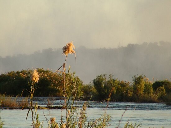
The Victoria Falls are considered the boundary between the upper and middle Zambezi. Below them the river continues to flow due east for about 200 kilometres (), cutting through perpendicular walls of basalt 20 to 60 metres (66 to 200 ft) apart in hills 200 to 250 metres (660 to 820 ft) high. The river flows swiftly through the Batoka gorge, the current being continually interrupted by reefs. It has been described[] as one of the world's most spectacular whitewater trips, a tremendous challenge for kayakers and rafters alike. Beyond the gorge are a succession of rapids which end 240 km (150 mi) below Victoria Falls. Over this distance, the river drops 250 metres (820 ft).
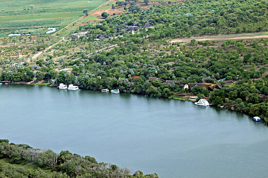
At this point, the river enters Lake Kariba, created in 1959 following the completion of the Kariba Dam. The lake is one of the largest man-made lakes in the world, and the hydroelectric power-generating facilities at the dam provide electricity to much of Zambia and Zimbabwe.
The Luangwa and the Kafue are the two largest left-hand tributaries of the Zambezi. The Kafue joins the main river in a quiet deep stream about 180 metres (590 ft) wide. From this point the northward bend of the Zambezi is checked and the stream continues due east. At the confluence of the Luangwa (15°37′ S) it enters Mozambique.
The middle Zambezi ends where the river enters Lake Cahora Bassa (also spelled Cabora Bassa). Formerly the site of dangerous rapids known as Kebrabassa, the lake was created in 1974 by the construction of the Cahora Bassa Dam.
The lower Zambezi's 650 km (400 mi) from Cahora Bassa to the Indian Ocean is navigable, although the river is shallow in many places during the dry season. This shallowness arises as the river enters a broad valley and spreads out over a large area. Only at one point, the Lupata Gorge, 320 km (200 mi) from its mouth, is the river confined between high hills. Here it is scarcely 200 m wide. Elsewhere it is from 5 to 8 km (3 to 5 mi) wide, flowing gently in many streams. The river bed is sandy, and the banks are low and reed-fringed. At places, however, and especially in the rainy season, the streams unite into one broad fast-flowing river.
About 160 km (100 mi) from the sea the Zambezi receives the drainage of Lake Malawi through the Shire River. On approaching the Indian Ocean, the river splits up into a number of branches and forms a wide delta. Each of the four principal mouths, Milambe, Kongone, Luabo and Timbwe, is obstructed by a sand bar. A more northerly branch, called the Chinde mouth, has a minimum depth at low water of 2 m at the entrance and 4 m further in, and is the branch used for navigation. 100 km (60 mi) further north is a river called the Quelimane, after the town at its mouth. This stream, which is silting up, receives the overflow of the Zambezi in the rainy season.
The delta of the Zambezi is today about half as broad as it was before the construction of the Kariba and Cahora Bassa dams controlled the seasonal variations in the flow rate of the river.
Before the dams were built seasonal flooding of the Zambezi had quite a different impact on the ecosytems of the delta from today as it brought nutritious fresh water down to the Indian Ocean coastal wetlands. The lower Zambezi experienced a small flood surge early in the dry season as rain in the Gwembe catchment and north-eastern Zimbabwe rushed through while rain in the Upper Zambezi, Kafue, and Lake Malawi basins, and Luangwa to a lesser extent, is held back by swamps and floodplains. The discharge of these systems contributed to a much larger flood in March or April, with a mean monthly maximum for April of 6,700 cubic metres (240,000 cu ft) per second at the delta. The record flood was more than three times as big, 22,500 cubic metres (790,000 cu ft) per second being recorded in 1958. By contrast the discharge at the end of the dry season averaged just 500 cubic metres (18,000 cu ft) per second.
In the 1960s and 1970s the building of dams changed that pattern completely. Downstream the mean monthly minimum–maximum was 500 cubic metres (18,000 cu ft) to 6,000 cubic metres (210,000 cu ft) per second; now it is 1,000 cubic metres (35,000 cu ft) to 3,900 cubic metres (140,000 cu ft) per second. Medium-level floods especially, of the kind to which the ecology of the lower Zambezi was adapted, happen less often and have a shorter duration. As with the Itezhi-Tezhi Dam's deleterious effects on the Kafue Flats, this has the following effects:
As well as the Zambezi this section applies to the Buzi, Pungwe, and Save rivers which also drain the Zambezi basin. Together the floodplains of these four river floodplains make up the World Wildlife Fund's Zambezian coastal flooded savanna ecoregion. They are a mixture of open grassland and freshwater swamp inland from the Indian Ocean in Mozambique.
Although the dams have stemmed some of the annual flooding of the lower Zambezi and caused the area of floodplain to be greatly reduced they have not removed flooding completely. They can't control extreme floods, they have just made medium-level floods less frequent. When heavy rain in the lower Zambezi combines with good runoff upstream, massive floods still happen and the wetlands are still an important habitat. However, as well as the shrinking of the wetlands further severe damage to wildlife was caused by uncontrolled hunting of animals such as buffalo and waterbuck during the Mozambique Civil War and now the conflict has ceased it is likely the floodplains will become more populated, and further damming has also been discussed. The only protected area of floodplain is the Marromeu Game Reserve near the city of Beira.
Although the region has seen a reduction in the populations of the large mammals it is still home to some including the Reedbuck and migrating eland. Carnivores found here include lion (Panthera leo), leopard (Panthera pardus), cheetah (Acinonyx jubatus), spotted hyena (Crocuta crocuta) and Side-striped jackal (Canis adustus). The floodplains are a haven for migratory waterbirds including Pintails, Garganey, African Openbill (Anastomus lamelligerus), Saddle-billed Stork (Ephippiorhynchus senegalensis), Wattled Crane, and Great White Pelican (Pelecanus onocrotalus).
Reptiles include Nile crocodile (Crocodylus niloticus), monitor lizard (Varanus niloticus) and python (Python sebae), the endemic Pungwe worm snake (Leptotyphlops pungwensis) and three other snakes that are nearly endemic; Floodplain Water Snake (Lycodonomorphus whytei obscuriventris), Dwarf wolf snake (Lycophidion nanus) and Eyebrow viper (Proatheris).
There are a number of endemic butterflies.
The north of the Zambezi basin has mean annual rainfall of 1100 to 1400 mm which declines towards the south, reaching about half that figure in the south-west. The rain falls in a 4 to 6 month summer rainy season when the Inter-Tropical Convergence Zone moves over the basin from the north between October and March. Evaporation rates are high (1600 mm−2300 mm) and much water is lost this way in swamps and floodplains, especially in the south-west of the basin.
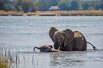
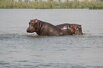
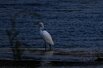
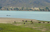
The river supports large populations of many animals. Hippopotamuses are abundant along most of the calm stretches of the river, and many crocodiles are also present. Monitor lizards are found in many places. Bird life is abundant, with species including heron, pelican, egret and African Fish Eagle present in large numbers. Riverine woodland also supports many large animals, such as buffalo, zebras, giraffes, elephants.
The Zambezi also supports several hundred species of fish, some of which are endemic to the river. Important species include cichlids which are fished heavily for food, as well as catfish, tigerfish, yellowfish and other large species. The bull shark is sometimes known as the Zambezi Shark after the river but is found around the world. It normally inhabits coastal waters but has been found far inland in many large rivers including the Zambezi. It is an aggressive shark which has been responsible for several attacks on humans.
Upper Zambezi: 507,200 km², discharges 1044 m³/s at Victoria Falls, comprising:
Northern Highlands catchment, 222,570 km², 850 m³/s at Lukulu:Middle Zambezi cumulatively 1,050,000 km², 2442 m³/s, measured at Cahora Bassa Gorge
(Middle section by itself: 542,800 km², discharges 1398 m³/s (C. Bassa–Victoria Falls) Gwembe Catchment, 156,600 km², 232 m³/s (Kariba Gorge–Vic Falls):Lower Zambezi cumulatively, 1,378,000 km², 3424 m³/s, measured at Marromeu
(Lower section by itself: 328,000 km², 982 m³/s (Marromeu–C. Bassa))Total Zambezi river basin: 1,390,000 km², 3424 m³/s discharged into delta
Source: Beilfuss & Dos Santos (2001) The Okavango Basin is not included in the figures because it only occasionally overflows to any extent into the Zambezi.
Due to the rainfall distribution, northern tributaries contribute much more water than southern ones, for example: the Northern Highlands catchment of the upper Zambezi contributes 25%, Kafue 8%, Luangwa and Shire Rivers 16% each, total 65% of Zambezi discharge. The large Cuando basin in the south-west on the other hand contributes only about 2 m³/s because most is lost through evaporation in its swamp systems. The 1940s and 1950s were particularly wet decades in the basin. Since 1975, it has been drier, the average discharge being only 70% of that for the years 1930 to 1958.
More than two million years ago, the Upper Zambezi river used to flow south through what is now the Makgadikgadi Pan to the Limpopo River. The land around the pan experienced tectonic uplift (perhaps as part of the African superswell) and a large lake formed, and extended east.
Meanwhile, 1,000 kilometres (620 mi) east, a western tributary of the Shire River in the Great Rift Valley's southern extension through Malawi eroded a deep valley on its western escarpment. At the rate of a few cm per year, this river, the Middle Zambezi, started cutting back the bed of its river towards the west, aided by grabens (rift valleys) forming along its course in an east-west axis. As it did so it captured a number of south-flowing rivers such as the Luangwa and Kafue.
Eventually the large lake trapped at Makgadikgadi (or a tributary of it) was captured by the Middle Zambezi cutting back towards it, and emptied eastwards. The Upper Zambezi was captured as well. The Middle Zambezi was about 300 metres (980 ft) lower than the Upper Zambezi, and a high waterfall formed at the edge of the basalt plateau across which the upper river flows. This was the first Victoria Falls, somewhere down the Batoka Gorge near where Lake Kariba is now. For details of how the falls cuts back its bed to form the gorge, see How the Victoria Falls formed.
and subsequent series of zigzagging gorges]]
The Zambezi region was known to medieval geographers as the Empire of Monomotapa, and the course of the river, as well as the position of Lakes Ngami and Nyasa, were given broadly accurately in early maps. These were probably constructed from Arab information.
The first European to visit the upper Zambezi was David Livingstone in his exploration from Bechuanaland between 1851 and 1853. Two or three years later he descended the Zambezi to its mouth and in the course of this journey discovered the Victoria Falls. During 1858–60, accompanied by John Kirk, Livingstone ascended the river by the Kongone mouth as far as the Falls, and also traced the course of its tributary the Shire and reached Lake Malawi.
For the next 35 years very little exploration of the river took place, but in 1889 the Chinde channel north of the main mouths of the river was discovered. Two expeditions led by Major A. St Hill Gibbons in 1895 to 1896 and 1898 to 1900 continued the work of exploration begun by Livingstone in the upper basin and central course of the river. Portuguese explorer Serpa Pinto examined some of the western tributaries of the river and made measurements of the Victoria Falls in 1878.
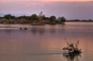
The population of the Zambezi river valley is estimated to be about 32 million. About 80% of the population of the valley is dependent on agriculture, and the upper river's flood plains provide good agricultural land.
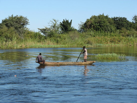
Communities by the river fish extensively from it, and many people travel from far afield to fish. Some Zambian towns on roads leading to the river levy unofficial 'fish taxes' on people taking Zambezi fish to other parts of the country. As well as fishing for food, game fishing is a significant activity on some parts of the river. Between Mongu and Livingstone, several safari lodges cater for tourists who want to fish for exotic species, and many also catch fish to sell to aquaria.
The river valley is rich in mineral deposits and fossil fuels, and coal mining is important in places. The dams along its length also provide employment for many people near them, in maintaining the hydroelectric power stations and the dams themselves. Several parts of the river are also very popular tourist destinations. Victoria Falls receives over 1.5 million visitors annually, while Mana Pools and Lake Kariba also draw substantial tourist numbers.
The river is frequently interrupted by rapids and so has never been an important long-distance transport route. David Livingstone's Zambezi Expedition attempted to open up the river to navigation by paddle steamer, but was defeated by the Cahora Bassa rapids. Along some stretches, it is often more convenient to travel by canoe along the river rather than on the unimproved roads which are often in very poor condition due to being regularly submerged in flood waters, and many small villages along the banks of the river are only accessible by boat. In the 1930s and 40s a paddle barge service operated on the stretch between the Katombora Rapids, about 50 kilometres (31 mi) upstream from Livingstone, and the rapids just upstream from Katima Mulilo. However, depending on the water level, boats could be paddled through—Lozi paddlers, a dozen or more in a boat, could deal with most of them—or they could be pulled along the shore or carried around the rapids, and teams of oxen pulled barges 5 kilometres (3.1 mi) over land around the Ngonye Falls.
Road, rail and other crossings of the river, once few and far between, are proliferating. They are, in order from the source:
There are a number of small pontoon ferries across the river in Angola, western Zambia, and Mozambique, notably between Mongu and Kalabo. Above Mongu in years following poor rainy seasons the river can be forded at one or two places. In tourist areas, such as Victoria Falls and Kariba, short-distance tourist boats take visitors along the river.
Sewage effluent is a major cause of water pollution around urban areas, as inadequate water treatment facilities in all the major cities of the region force them to release untreated sewage into the river. This has resulted in eutrophication of the river water and has facilitated the spread of diseases of poor hygiene such as cholera, typhus and dysentery.
The construction of two major dams regulating the flow of the river has had a major effect on wildlife and human populations in the lower Zambezi region. When the Cahora Bassa Dam was constructed in 1973, its managers allowed it to fill in a single flood season, going against recommendations to fill over at least two years. The drastic reduction in the flow of the river led to a 40% reduction in the coverage of mangroves, greatly increased erosion of the coastal region and a 60% reduction in the catch of prawns off the mouth due to the reduction in emplacement of silt and associate nutrients. Wetland ecosystems downstream of the dam shrank considerably. Wildlife in the delta was further threatend by uncontrolled hunting during the civil war in Mozambique.
The transfrontier Okavango-Zambezi Conservation Park will cover parts of Zambia, Angola, Namibia, Zimbabwe and Botswana, including the famous Okavango Delta in Botswana and Mosi-oa-Tunya (The Smoke That Thunders, or Victoria Falls). It is thought that the cross-border park will help with animal migration routes and assist in the preservation of wetlands which clean water, as sewage from communities is a problem.
Funding boost for cross-border conservation project along the Zambezi in 2008. The Okavango–Zambezi Transfrontier Conservation project—which follows the Zambezi River and stretches across Angola, Botswana, Namibia, Zambia and Zimbabwe—has received a grant of €8 million from a German nongovernmental organisation. Part of the funds will be used for research in areas covered by the project. However, Angola has warned that landmines from their civil war may impede the project.
On 14 September 2007, epizootic ulcerative syndrome (EUS) killed hundreds of sore-covered fish in River Zambezi. Zambia Agriculture Minister Ben Kapita asked experts to investigate the outbreak to probe the cause to find out if the disease can be transmitted to humans.
Along much of the river's length, the population is sparse, but important towns and cities along its course include the following:
This article incorporates text from the Encyclopædia Britannica, Eleventh Edition', a publication now in the public domain.


