Lake Superior is the largest of the five Great Lakes of North America. (Lake Michigan and Lake Huron are traditionally regarded as two lakes, though hydrologically they form one, and if Michigan-Huron is considered as one lake, then Lake Superior is the second largest of the Great Lakes.) It is bounded to the north by Ontario, Canada and Minnesota, United States, and to the south by the U.S. states of Wisconsin and Michigan. It is the second largest freshwater lake in the world by surface area and is the world's fourth-largest freshwater lake by volume.
In the Ojibwe language, the lake is called Gichigami, meaning "big water". It is also written "Gitche Gumee" as recorded by Henry Wadsworth Longfellow in The Song of Hiawatha.
The lake was named le lac supérieur, or "Upper Lake," in the seventeenth century by French explorers because it was located above Lake Huron. It was also known as Lac Tracy during the French regime.(Nute, 1946)
Lake Superior is the largest freshwater lake in the world by surface area, and empties into nearby Lake Michigan and Huron. Lake Baikal in Russia is larger by volume, as is Lake Tanganyika. The Caspian Sea, while larger than Lake Superior in both surface area and volume, is brackish; though presently isolated, historically the Caspian has been repeatedly connected to and isolated from the Mediterranean via the Black Sea.
Lake Superior has a surface area of Шаблон:Convert — which is larger than South Carolina. It has a maximum length of Шаблон:Convert and maximum breadth of Шаблон:Convert. Its average depth is Шаблон:Convert with a maximum depth of Шаблон:Convert. Lake Superior contains 2,900 cubic miles (12,100 km³) of water. There is enough water in Lake Superior to cover the entire land mass of North and South America with Шаблон:Convert of water. The shoreline of the lake stretches Шаблон:Convert (including islands). The lake's elevation is Шаблон:Convert above sea level. American limnologist J. Val Klump was the first person to reach the lowest depth of Lake Superior on July 30, 1985, as part of a scientific expedition, which, at Шаблон:Convert below sea level, is the lowest spot on the continental interior of the United States and the second lowest spot on the interior of the North American continent after the much deeper Great Slave Lake in Canada (Шаблон:Convert below sea level). (Though Crater Lake, not Lake Superior, is the deepest lake in the United States, Crater Lake's surface elevation is much higher and its deepest point is Шаблон:Convert above sea level.) The average temperature of the lake during the summer is about 40 degrees farenheit.
Annual storms on Lake Superior regularly record wave heights of over Шаблон:Convert. Waves well over Шаблон:Convert have been recorded.
Until approximately 1887, the natural hydraulic conveyance through the St. Marys River rapids determined outflow from Lake Superior. By 1921, development in support of transportation and hydropower resulted in gates, locks, power canals, and other control structures completely spanning St. Marys rapids. The regulating structure is known as the Compensating Works and is operated according to a regulation plan known as Plan 1977-A. The current water levels, including diversions of water from the Hudson Bay watershed, are governed by the International Lake Superior Board of Control which was established in 1914 by the International Joint Commission.
The lake is fed by over 200 rivers. The largest include the Nipigon River, the St. Louis River, the Pigeon River, the Pic River, the White River, the Michipicoten River, the Brule River and the Kaministiquia River. Lake Superior drains into Lake Huron by the St. Marys River. The rapids on the river necessitate the Sault Locks (pronounced "soo"), a part of the Great Lakes Waterway, to move boats over the Шаблон:Convert height difference from Lake Huron.
The largest island in Lake Superior is Isle Royale in the state of Michigan. Isle Royale contains several lakes, some of which also contain islands. Other large famous islands include Madeline Island in the state of Wisconsin and Michipicoten in the province of Ontario.
The larger cities on Lake Superior include: the twin ports of Duluth, Minnesota, and Superior, Wisconsin; Thunder Bay, Ontario; Marquette, Michigan; and the two cities of Sault Ste. Marie, in Michigan and in Ontario. Duluth, at the western tip of Lake Superior, is the most inland point on the St. Lawrence Seaway and the most inland port in the world.
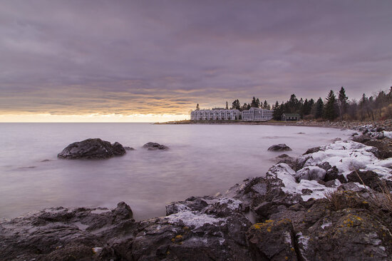
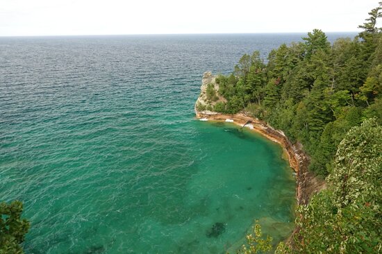
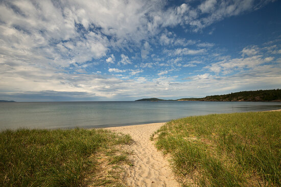
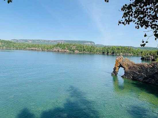
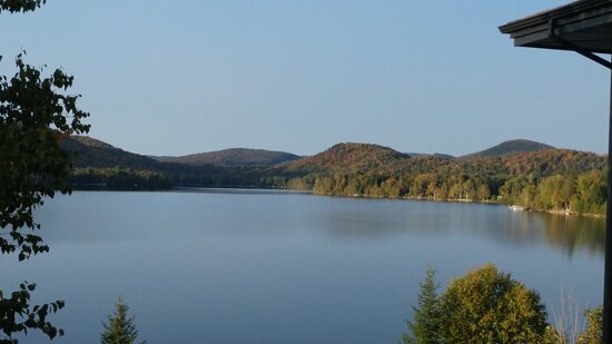
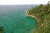
Among the scenic places on the lake are: the Apostle Islands National Lakeshore; Isle Royale National Park; Porcupine Mountains Wilderness State Park; Pukaskwa National Park; Lake Superior Provincial Park; Grand Island National Recreation Area; Sleeping Giant (Ontario);and Pictured Rocks National Lakeshore.
The Great Lakes Circle Tour is a designated scenic road system connecting all of the Great Lakes and the St. Lawrence River.
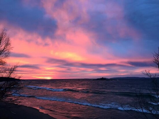
Lake Superior's size creates a localized oceanic or maritime climate (more typically seen in locations like Nova Scotia). The water surface's slow reaction to temperature changes, seasonally ranging between 32°-55°F (0°-13°C) around 1970, helps to moderate surrounding air temperatures in the summer and winter, and creates lake effect snow in colder months. The hills and mountains that border the lake hold moisture and fog, particularly in the fall. The lake's surface temperature has risen by 4.5 Fahrenheit degrees (2.5 Celsius degrees) since 1979, which is attributed to global warming.
of the U.S. area bordering Lake Superior: Minnesota, Wisconsin, and the Upper Peninsula of Michigan.]]
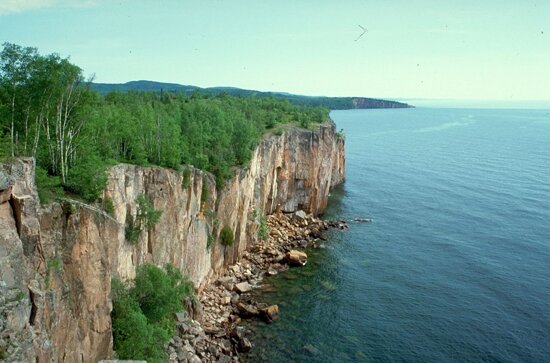
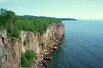
The rocks of Lake Superior's North Shore date back to the early history of the earth. During the Precambrian (between 4.5 billion and 540 million years ago), magma forcing its way to the surface created the intrusive granites of the Canadian Shield. These ancient granites can be seen on the North Shore today. It was during the Penokean orogeny, that many valuable metals were deposited. The region surrounding the lake has proved to be rich in minerals. Copper, iron, silver, gold and nickel are or were the most frequently mined. Examples include the Hemlo gold mine near Marathon, copper at Point Mamainse, silver at Silver Islet, and uranium at Theano Point.
and basement rock, showing the formation of the Midcontinent Rift containing today's Lake Superior.]]
The mountains steadily eroded, depositing layers of sediments which compacted and became limestone, dolostone, taconite, and the shale at Kakabeka Falls.
The continent was later riven, creating one of the deepest rifts in the world. The lake lies in this long-extinct Mesoproterozoic rift valley, the Midcontinent Rift. Magma was injected between layers of sedimentary rock, forming diabase sills. This hard diabase protects the layers of sedimentary rock below, forming the flat-topped mesas in the Thunder Bay area. Amethyst formed in some of the cavities created by the Midcontinent Rift, and there are several amethyst mines in the Thunder Bay area.
Lava erupted from the rift and formed the black basalt rock of Michipicoten Island, Black Bay Peninsula, and St. Ignace Island.
During the Wisconsin glaciation 10,000 years ago, ice covered the region at a thickness of Шаблон:Convert. The land contours familiar today were carved by the advance and retreat of the ice sheet. The retreat left gravel, sand, clay, and boulder deposits. Glacial meltwaters gathered in the Superior basin creating Lake Minong, a precursor to Lake Superior. Without the immense weight of the ice, the land rebounded, and a drainage outlet formed at Sault Ste. Marie, which would become known as St. Mary's River.
at Lake Superior Provincial Park, Ontario]]
The first people came to the Lake Superior region 10,000 years ago after the retreat of the glaciers in the last Ice Age. They are known as the Plano, and they used stone-tipped spears to hunt caribou on the northwestern side of Lake Minong.
The next documented people were known as the Shield Archaic (c. 5000-500 BC). Evidence of this culture can be found at the eastern and western ends of the Canadian shore. They used bows and arrows, dugout canoes, fished, hunted, mined copper for tools and weapons, and established trading networks. They are believed to be the direct ancestors of the Ojibwe and Cree.
The Laurel people (c. 500 BC to AD 500) developed seine net fishing, evidence being found at rivers around Superior such as the Pic and Michipicoten.
Another culture known as the Terminal Woodland Indians (c. AD 900-1650) has been found. They were Algonkian people who hunted, fished and gathered berries. They used snow shoes, birch bark canoes and conical or domed lodges. At the mouth of the Michipicoten River, nine layers of encampments have been discovered. Most of the Pukaskwa Pits were likely made during this time.
The Anishinaabe, also known as the Ojibwe or Chippewa, have inhabited the Lake Superior region for over five hundred years and were preceded by the Dakota, Fox, Menominee, Nipigon, Noquet, and Gros Ventres. They called Lake Superior Anishnaabe Chi Gaming, or "the Ojibwe's Ocean". After the arrival of Europeans, the Anishinaabe made themselves the middle-men between the French fur traders and other Native peoples. They soon became the dominant Indian nation in the region: they forced out the Sioux and Fox and won a victory against the Iroquois west of Sault Ste. Marie in 1662. By the mid-18th century, the Ojibwe occupied all of Lake Superior's shores.
In the 18th century, the fur trade in the region was booming, with the Hudson's Bay Company having a virtual monopoly. In 1783, however, the North West Company was formed to rival Hudson's Bay Company. The North West Company built forts on Lake Superior at Grand Portage, Nipigon, the Pic River, the Michipicoten River, and Sault Ste. Marie. But by 1821, with competition taking too great a toll on both, the companies merged under the Hudson's Bay Company name.
Many towns around the lake are either current or former mining areas, or engaged in processing or shipping. Today, tourism is another significant industry; the sparsely populated Lake Superior country, with its rugged shorelines and wilderness, attracts tourists and adventurers.
Lake Superior has been an important link in the Great Lakes Waterway, providing a route for the transportation of iron ore and other mined and manufactured materials. Large cargo vessels called lake freighters, as well as smaller ocean-going freighters, transport these commodities across Lake Superior.
, a large lake freighter, sank in 1975]]
Шаблон:Seealso Шаблон:Seealso The last major shipwreck on Lake Superior was that of SS Edmund Fitzgerald on November 10, 1975.
According to legend, Lake Superior never gives up her dead. This is because of the unusually low temperature of the water, estimated at under Шаблон:Convert on average around 1970. Normally bacteria feeding on a sunken decaying body will generate gas inside the body, causing it to float to the surface after a few days. The water in Lake Superior is cold enough year-round to inhibit bacterial growth, and bodies tend to sink and never surface. This is alluded to in Gordon Lightfoot's ballad, "The Wreck of the Edmund Fitzgerald". The Edmund Fitzgerald's 29 crew members all perished, and not one of the bodies was ever found. The Fitzgerald got swallowed up so intensely by Lake Superior, that the Шаблон:Convert ship split in half. Its two pieces are sitting approximately Шаблон:Convert apart in a depth of Шаблон:Convert.
Storms that claimed multiple ships include the Mataafa Storm on November 28, 1905, and the Great Lakes Storm of 1913.
In August 2007, wreckage was found of the Cyprus, a Шаблон:Convert ore carrier which sank during a Lake Superior storm in Шаблон:Convert of water. All but Charles G. Pitz of the Cyprus’ 23 crew perished on October 11, 1907. The ore carrier sank in Lake Superior on its second voyage, whilst hauling iron ore from Superior, Wisconsin, to Buffalo, New York. Built in Lorain, Ohio, the Cyprus was launched August 17, 1907.
Although part of a single system, each of the Great Lakes is different. In volume, Lake Superior is the largest. It is also the deepest and coldest of the five. Superior could contain all the other Great Lakes and three more Lake Eries. Because of its size, Superior has a retention time of 191 years.
Superior's water levels temporarily reached a new low in September 2007, slightly less than the previous record low in 1926. However, the water levels soon returned within a few days.
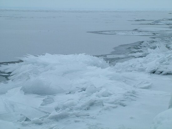
According to a study by professors at the University of Minnesota Duluth, Lake Superior may have warmed faster than its surrounding climate. Summer surface temperatures in the lake appeared to have increased about 4.5 Fahrenheit degrees (2.5 Celsius degrees) since 1979, compared with a approximately 2.7 Fahrenheit degree (1.5 Celsius degree) increase in the surrounding average air temperature. The increase in the lake’s surface temperature may be related to the decreasing ice cover. Less winter ice cover allows more solar radiation to penetrate the lake and warm the water. If trends continue Lake Superior, which freezes over completely once every 20 years, could routinely be ice-free by 2040. These warmer temperatures can actually lead to more snow in the lake effect snow belts along the shores of the lake, especially in the Upper Peninsula of Michigan.
Over sixty species of fish have been found in Lake Superior, among them: bloater, brook trout, brown trout, burbot, carp, chinook salmon, coho salmon, freshwater drum, lake herring, lake sturgeon, lake trout, lake whitefish, longnose sucker, muskellunge, northern pike, pumpkinseed, pink salmon, rainbow smelt, rainbow trout, rock bass, round goby, round whitefish, ruffe, sea lamprey, smallmouth bass, walleye, white perch, white sucker, and yellow perch.
Lake Superior has fewer dissolved nutrients relative to its size compared to the other Great Lakes and so is less productive in terms of fish populations. This is a result of the underdeveloped soils found in its relatively small watershed. However, nitrate concentrations in the lake have been continuously rising for more than a century. They are still much lower than levels considered dangerous to human health, but this steady, long-term rise is an unusual record of environmental nitrogen buildup. It may relate to anthropogenic alternations to the regional Nitrogen Cycle, but researchers are still unsure of the causes of this change to the lake's ecology. As for other Great Lakes, fish populations have also been impacted by the accidental or intentional introduction of foreign species such as the sea lamprey and Eurasian ruffe. Accidental introductions have occurred in part by the removal of natural barriers to navigation between the Great Lakes. Overfishing has also been a factor in the decline of fish populations.